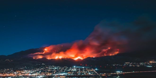
The recent 2020 US West Coast wildfire has opened infernos, as it ravaged hundreds of homes and charred hundreds of neighborhoods. On September 10, 2020, CNN announced that the Creek Fire had taken more than 166,00 acres after destroying 360 structures in Central California, Amidst a state emergency, firefighters had to defeat the “beast” that turned the scenery to a similar fiction movies scene on a doomsday. Wildfire causes environmental disasters that were attributed by many scientists to climate change. The preparedness, detection, and management of wildfires and other environmental disasters, that affected the environment hinge on satellite technologies, essentially, the Remote Sensing of sea surfaces and land areas, and the civil space-based Earth Observation and its applications. Such space-based technologies are deployed to assess, monitor, and manage local, regional, and large-scale transboundary environmental issues that impact the societies, economies, and ecosystems. Thanks to its large areas’ data collection and high-frequency capabilities Earth Observation, in particular, has become a powerful tool to monitor the terrestrial environment and manage environmental disasters as it be addressed in this article.
Satellite technologies have been used to understand climate change better to find solutions to mitigate its deteriorating consequences, such as hurricanes, droughts, rising sea levels, melting polar ice caps, wildfire, and floods. Scientists relied upon various observation systems and satellite technologies, networks of weather balloons, buoys, and thermometer, to collect climate change’s evidence from the depths of the oceans to the top of Earth’s atmosphere. For instance, EO is relied upon to map the greenhouse gases. Earth Observation (EO) monitors the carbon dioxide (CO2) concentration, the second most abundant greenhouse gas component after water vapor, satellite monitored through water management, and weather forecast [1]. Public and private entities harnessed spectroscopy and satellites to monitor externalities data from various sources.