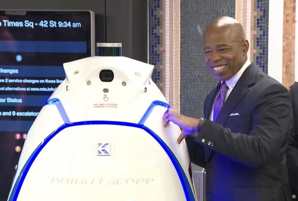
Toggle light / dark theme

Autonomous drone mapping startup Emesent has announced its latest survey-grade LiDAR payload: Hovermap ST. The lightweight, IP65-rated solution is being launched with Emesent’s new Automated Ground Control feature that, the company stresses, enables autonomous data capture in harsher environments than ever and for a wider range of use cases.

Emesent’s LiDAR payloads leverage a process called simultaneous localization and mapping (SLAM), in which a drone builds a map and, at the same time, localizes the drone in that map.

The Santa Cruz Mountains define the geography of the Bay Area south of San Francisco, protecting the peninsula from the Pacific Ocean’s cold marine layer and forming the region’s notorious microclimates. The range also represents the perils of living in Silicon Valley: earthquakes along the San Andreas fault.

In bursts that last seconds to minutes, earthquakes have moved the region’s surface meters at a time. But researchers have never been able to reconcile the quick release of the Earth’s stress and the bending of the Earth’s crust over years with the formation of mountain ranges over millions of years. Now, by combining geological, geophysical, geochemical and , geologists have created a 3D tectonic model that resolves these timescales.

The research, which appears in Science Advances Feb. 25, reveals that more mountain building happens in the period between along the San Andreas Fault, rather than during the quakes themselves. The findings may be used to improve local seismic hazard maps.

Scientists from Nanyang Technological University, Singapore (NTU Singapore), have developed a fast and low-cost imaging method that can analyze the structure of 3D-printed metal parts and offer insights into the quality of the material.

Most 3D-printed metal alloys consist of a myriad of microscopic crystals, which differ in shape, size, and atomic lattice orientation. By mapping out this information, scientists and engineers can infer the alloy’s properties, such as strength and toughness. This is similar to looking at wood grain, where wood is strongest when the grain is continuous in the same direction.

This new made-in-NTU technology could benefit, for example, the aerospace sector, where low-cost, rapid assessment of mission critical parts—turbine, fan blades and other components—could be a gamechanger for the maintenance, repair and overhaul industry.

Researchers from the University of Oxford’s Big Data Institute have taken a major step towards mapping the entirety of genetic relationships among humans: a single genealogy that traces the ancestry of all of us. The study has been published today in Science.

“We saw a very large coronal mass ejection, which is a major storm on the sun,” Todd explained. “It happened on the far side, which is awfully good because it was enormous.”

Though the explosive CME is not expected to strike Earth, images captured by satellite and seismic mapping showing the sheer size of the eruption had many people talking, Todd said.

Todd said scientists estimate the flare stretched to roughly 400,000 kilometers, greater than the distance between the Earth and the Moon.

We construct quantum algorithms to compute physical observables of nonlinear PDEs with M initial data. Based on an exact mapping between nonlinear and linear PDEs using the level set method, these new quantum algorithms for nonlinear Hamilton-Jacobi and scalar hyperbolic PDEs can be performed with a computational cost that is independent of M, for arbitrary nonlinearity. Depending on the details of the initial data, it can also display up to exponential advantage in both the dimension of the PDE and the error in computing its observables. For general nonlinear PDEs, quantum advantage with respect to M is possible in the large M limit.

In a paper published by Science, DeepMind demonstrates how neural networks can improve approximation of the Density Functional (a method used to describe electron interactions in chemical systems). This illustrates deep learning’s promise in accurately simulating matter at the quantum mechanical.


In a paper published in the scientific journal Science, DeepMind demonstrates how neural networks can be used to describe electron interactions in chemical systems more accurately than existing methods.

Density Functional Theory, established in the 1960s, describes the mapping between electron density and interaction energy. For more than 50 years, the exact nature of mapping between electron density and interaction energy — the so-called density functional — has remained unknown. In a significant advancement for the field, DeepMind has shown that neural networks can be used to build a more accurate map of the density and interaction between electrons than was previously attainable.

By expressing the functional as a neural network and incorporating exact properties into the training data, DeepMind was able to train the model to learn functionals free from two important systematic errors — the delocalization error and spin symmetry breaking — resulting in a better description of a broad class of chemical reactions.

13 Aug 2021

“The proportions of different isotopes of elements present in the bedrock and water create a unique profile, specific to each place on Earth. This profile remains consistent over the millennia and is a kind of “fingerprint” of a region, which can be found in plants, rocks and even animal remains.” National Geographic Poland.

“One of the mammoth’s tusks became a perfect record of all the places the animal visited in its lifetime — with an accuracy almost to the day.”


An international research team has retraced the astonishing lifetime journey of an Arctic woolly mammoth, which covered enough of the Alaska landscape during its 28 years to almost circle the Earth twice.

The U.S. Army has awarded a $20 million a year contract to a California-based drone manufacturer, named Skydio, as part of its efforts to move away from foreign-made and commercially available off-the-shelf drones. Skydio revealed in a press release that it would supply its X2D drones for the U.S. Army’s Short Range Reconnaissance (SSR) Program.

With an aim to equip its soldiers with rapidly deployable aerial solutions that can conduct reconnaissance and surveillance activities over short ranges, the Army’s SSR program has been considering small drones for some time now. More than 30 vendors submitted their proposals to the Army, and five finalists were shortlisted for rigorous testing.

The Drive accessed a federal contract from 2017 that listed the minimal specifications of the SSR program which include a flight time of 30 minutes, a range of 1.86 nautical miles (3 km), and the ability to tolerate winds up to 15 knots. With the singular purpose of reconnaissance, the drone does not need to have swappable payloads but it should support mapping missions and the ability to geotag imagery. U.S. Army has awarded a $20 million a year contract to a California-based drone manufacturer, named Skydio, as part of its efforts to move away from foreign-made and commercially available off-the-shelf drones. Skydio revealed in a press release that it would supply its X2D drones for the U.S. Army’s Short Range Reconnaissance (SSR) Program.