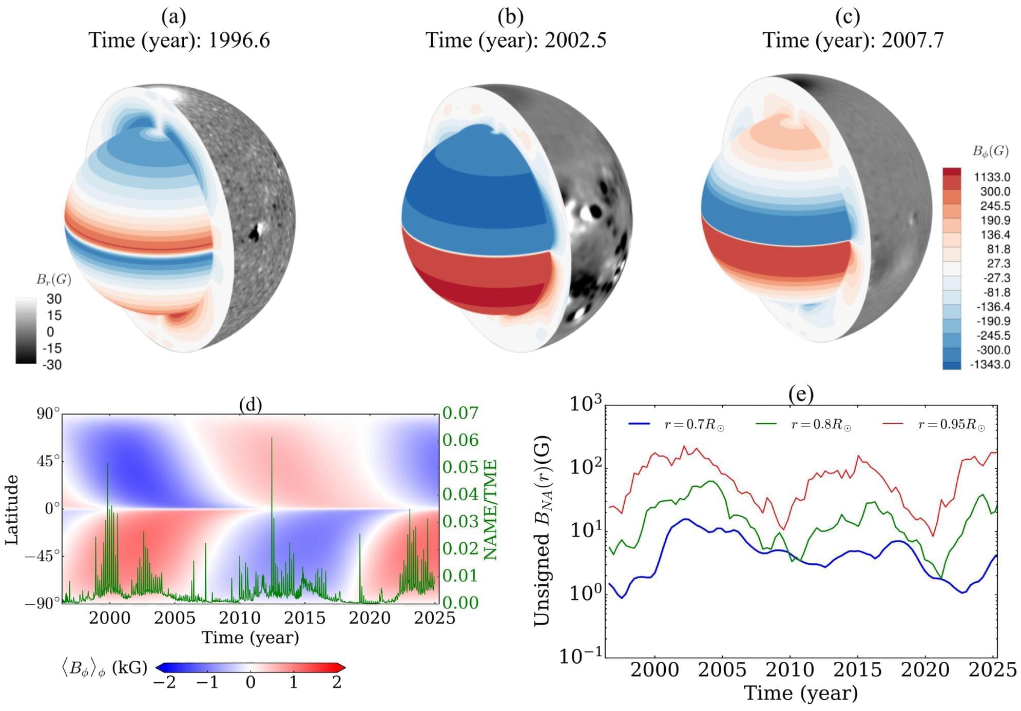
БЛОГ

Archive for the ‘mapping’ category: Page 6

Mar 22, 2022

MIT scientists mapped the dark side of a hot Jupiter exoplanet in amazing detail

Posted by in categories: mapping, space

Mar 19, 2022

Pioneering AI Technique Accurately Recognizes Earth’s Natural Features in Detail for Better Environmental Maps

Posted by in categories: mapping, robotics/AI

Scientists have developed a new artificial intelligence (AI) technology that models and maps the natural environment in intricate detail. Check out how this could help scientists in their work.

Mar 15, 2022

Mapping how the 100 billion cells in the brain all fit together is the brave new world of neuroscience

Posted by in categories: mapping, neuroscience

These steps are repeated for each cell type, creating a richer and more complete map of the brain with each run-through.

Working together to build a brain map

Continue reading “Mapping how the 100 billion cells in the brain all fit together is the brave new world of neuroscience” »

Mar 11, 2022

What’s On The Other Side Of A Black Hole?

Posted by in categories: cosmology, mapping

PBS Member Stations rely on viewers like you. To support your local station, go to: http://to.pbs.org/DonateSPACE
↓ More info below ↓

Sign Up on Patreon to get access to the Space Time Discord!
https://www.patreon.com/pbsspacetime.

Continue reading “What’s On The Other Side Of A Black Hole?” »

Mar 2, 2022

How did Google Maps’ traffic data become a tool for the Ukraine war?

Posted by in categories: information science, mapping

Mar 1, 2022

Emesent launches Hovermap ST autonomous drone LiDAR mapping and surveying payload

Posted by in categories: drones, mapping, robotics/AI

Autonomous drone mapping startup Emesent has announced its latest survey-grade LiDAR payload: Hovermap ST. The lightweight, IP65-rated solution is being launched with Emesent’s new Automated Ground Control feature that, the company stresses, enables autonomous data capture in harsher environments than ever and for a wider range of use cases.

Emesent’s LiDAR payloads leverage a process called simultaneous localization and mapping (SLAM), in which a drone builds a map and, at the same time, localizes the drone in that map.

Feb 25, 2022

New model may improve Bay Area seismic hazard maps

Posted by in categories: chemistry, mapping

The Santa Cruz Mountains define the geography of the Bay Area south of San Francisco, protecting the peninsula from the Pacific Ocean’s cold marine layer and forming the region’s notorious microclimates. The range also represents the perils of living in Silicon Valley: earthquakes along the San Andreas fault.

In bursts that last seconds to minutes, earthquakes have moved the region’s surface meters at a time. But researchers have never been able to reconcile the quick release of the Earth’s stress and the bending of the Earth’s crust over years with the formation of mountain ranges over millions of years. Now, by combining geological, geophysical, geochemical and , geologists have created a 3D tectonic model that resolves these timescales.

The research, which appears in Science Advances Feb. 25, reveals that more mountain building happens in the period between along the San Andreas Fault, rather than during the quakes themselves. The findings may be used to improve local seismic hazard maps.

Feb 25, 2022

Scientists invent imaging method to assess quality of 3D-printed metal parts

Posted by in categories: mapping, materials

Scientists from Nanyang Technological University, Singapore (NTU Singapore), have developed a fast and low-cost imaging method that can analyze the structure of 3D-printed metal parts and offer insights into the quality of the material.

Most 3D-printed metal alloys consist of a myriad of microscopic crystals, which differ in shape, size, and atomic lattice orientation. By mapping out this information, scientists and engineers can infer the alloy’s properties, such as strength and toughness. This is similar to looking at wood grain, where wood is strongest when the grain is continuous in the same direction.

This new made-in-NTU technology could benefit, for example, the aerospace sector, where low-cost, rapid assessment of mission critical parts—turbine, fan blades and other components—could be a gamechanger for the maintenance, repair and overhaul industry.

Feb 25, 2022

“A Genealogy for All of Humanity” — University of Oxford Researchers Create Largest Ever Human Family Tree

Posted by in categories: genetics, information science, mapping

Researchers from the University of Oxford’s Big Data Institute have taken a major step towards mapping the entirety of genetic relationships among humans: a single genealogy that traces the ancestry of all of us. The study has been published today in Science.

Feb 24, 2022

Maps: Tracking the Russian Invasion of Ukraine

Posted by in categories: mapping, transportation

Russia launched attacks on major cities and airports across Ukraine, shelling more than a dozen cities and towns and crossing the border in multiple locations.

Page 6 of 26First345678910Last