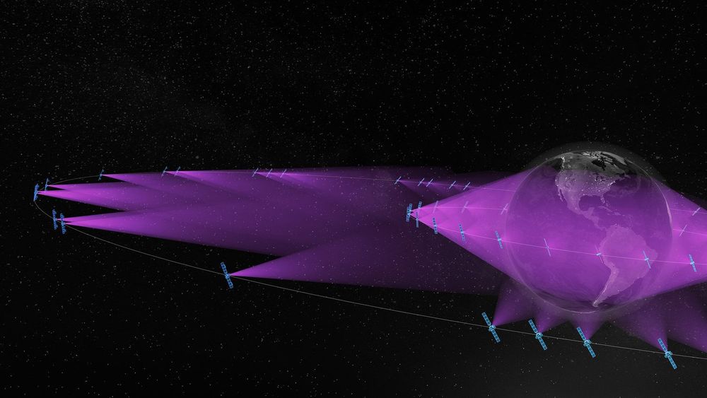
Toggle light / dark theme

WASHINGTON — DirecTV is racing to move its Spaceway-1 satellite out of the geostationary arc after the 15-year-old satellite suffered a crippling battery malfunction that the company fears could cause it to explode.

DirecTV told the U.S. Federal Communications Commission that it does not have time to deplete the remaining fuel on Spaceway-1 before disposing of it by boosting it 300 kilometers above the geostationary arc, a region home to most of the world’s large communications satellites.

Spaceway-1 is a Boeing-built High Power 702 model satellite that was designed to last 12 years. Launched in 2005 on a Sea Launch Zenit 3SL rocket, the 6,080-kilogram satellite originally provided high-definition television direct broadcasting services from its orbital slot at 102.8 degrees west longitude. More recently, Spaceway-1 was being used to backup Ka-band capacity over Alaska.

SAN FRANCISCO – Startup Skylo emerged from stealth mode Jan. 21 with $116 million in the bank and plans to connect devices by transferring data over existing geostationary communications satellites.

“The key challenge we wanted to address was how data was going to be moved from machines and sensors outside of the areas where traditionally connectivity has existed,” Parthsarathi “Parth” Trivedi, Skylo co-founder and CEO, told SpaceNews. “If we could lower the cost of providing ubiquitous, affordable and reliable connectivity, there would be a phenomenal number of applications.”

Skylo raised $13 million in a Series A investment round led by DCM Ventures and Innovation Endeavors with participation by Boeing HorizonX and Moore Strategic Ventures. In its latest Series B round led by SoftBank with participation by all the firm’s previous investors, Skylo raised $103 million, according to the firm’s Jan. 21 news release.

Satellite and Earth observation startup Capella Space has unveiled a new design for its satellite technology, which improves upon its existing testbed hardware platform to deliver high-resolution imaging capable of providing detail at less than 0.5 meters (1.6 feet). Its new satellite, code-named “Sequoia,” also will be able to provide real-time tasking, meaning Capella’s clients will be able to get imaging from these satellites of a desired area basically on demand.

Capella’s satellites are “synthetic aperture radar” (SAR for short) imaging satellites, which means they’re able to provide 2D images of the Earth’s surface even through cloud cover, or when the area being imaged is on the night side of the planet. SAR imaging resolution is typically much higher than the 0.5-meter range that Capella’s new design will enable — and it’s especially challenging to get that kind of performance from small satellites, which is what Sequoia will be.

The new satellite design is a “direct result of customer feedback,” Capella says, and includes advancements like an improved solar array for faster charging and quicker recycling; better thermals to allow it to image for longer stretches at a time; a much more agile targeting array, which means it can switch targets much more quickly in response to customer needs; and a higher bandwidth downlink, meaning it can transfer more data per orbital pass than any other SAR system from a commercial company in its size class.

SAN FRANCISCO – Radar satellite operator Iceye released a product Jan. 20 to detect dark vessels, ships at sea that are not identifying themselves with Automatic Identification System (AIS) transponders.

Iceye combines observations from its constellation of three synthetic aperture radar satellites with other data sources to provide customers with radar satellite images of vessels that are not broadcasting their identification, position and course with AIS transponders. The technology is designed to help government agencies, nongovernmental organizations and commercial customers curb drug and human trafficking, find illegal fishing vessels and enforce rules against illegal transshipment of goods, Finland-based Iceye said in a Jan. 20 news release.

Dark vessel detection is a popular application for radar satellites which gather data day, night and in all weather conditions, Pekka Laurila, Iceye co-founder and chief strategy officer told SpaceNews. With three satellites in orbit, Iceye offers customers the ability to frequently revisit areas of interest. In addition, the company has developed machine learning algorithms to speed up dark vessel detection, he added.

Launching in late 2021, Lucy will be the first space mission to explore the Trojan asteroids. These are a population of small bodies that are left over from the formation of the solar system. They lead or follow Jupiter in their orbit around the Sun, and they may tell us about the origins of organic materials on Earth.

Lucy will fly by and carry out remote sensing on six different Trojan asteroids and will study surface geology, surface color and composition, asteroid interiors/bulk properties, and will look at the satellites and rings of the Trojans.

SET-listed satellite service provider Thaicom is in talks with three foreign companies on partnership deals to operate ground stations for satellite data transmission as the government works towards opening the satellite industry to private operators through a licensing regime.

The ground stations, known as satellite gateways, are responsible for transmitting data to and from the satellite to the local area network. The antennas and equipment for converting the radio frequency signal to an internet protocol signal for terrestrial connectivity are already installed.

The deals are expected to be concluded this year, with operations kicking off next year, according to Thaicom chief executive Anant Kaewruamgvongs.