БЛОГ

Archive for the ‘satellite’ tag

Apr 22, 2020

Dengue case predictor mapping system wins the 2019 NASA global hackathon

Posted by in categories: astronomy, big data, computing, disruptive technology, environmental, events, hacking, information science, innovation, machine learning, mapping, open source, satellites, science, software, space
Upper row Associate American Corner librarian Donna Lyn G. Labangon, Space Apps global leader Dr. Paula S. Bontempi, former DICT Usec. Monchito B. Ibrahim, Animo Labs executive director Mr. Federico C. Gonzalez, DOST-PCIEERD deputy executive director Engr. Raul C. Sabularse, PLDT Enterprise Core Business Solutions vice president and head Joseph Ian G. Gendrano, lead organizer Michael Lance M. Domagas, and Animo Labs program manager Junnell E. Guia. Lower row Dominic Vincent D. Ligot, Frances Claire Tayco, Mark Toledo, and Jansen Dumaliang Lopez of Aedes project.

MANILA, Philippines — A dengue case forecasting system using space data made by Philippine developers won the 2019 National Aeronautics and Space Administration’s International Space Apps Challenge. Over 29,000 participating globally in 71 countries, this solution made it as one of the six winners in the best use of data, the solution that best makes space data accessible, or leverages it to a unique application.

Dengue fever is a viral, infectious tropical disease spread primarily by Aedes aegypti female mosquitoes. With 271,480 cases resulting in 1,107 deaths reported from January 1 to August 31, 2019 by the World Health Organization, Dominic Vincent D. Ligot, Mark Toledo, Frances Claire Tayco, and Jansen Dumaliang Lopez from CirroLytix developed a forecasting model of dengue cases using climate and digital data, and pinpointing possible hotspots from satellite data.

Sentinel-2 Copernicus and Landsat 8 satellite data used to reveal potential dengue hotspots.

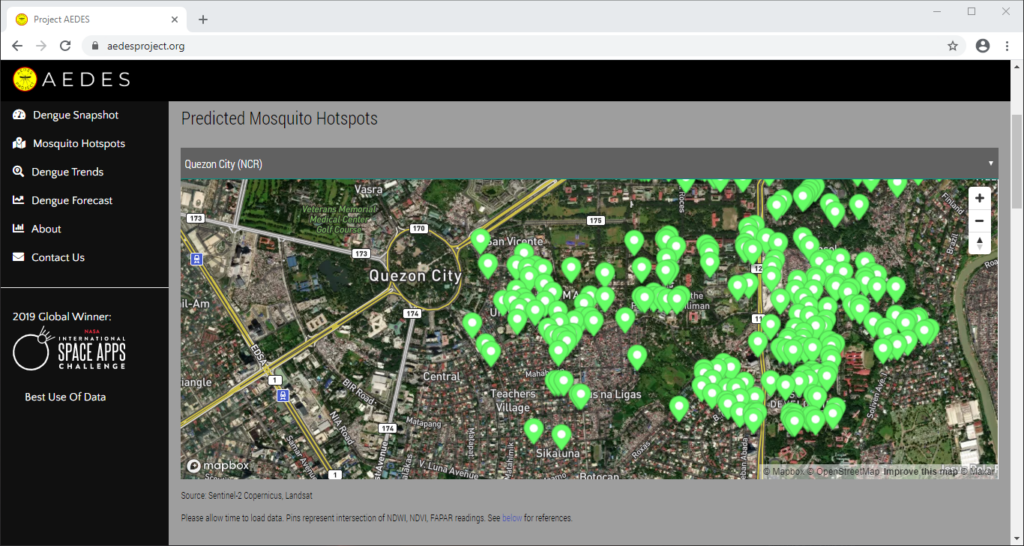
Correlating information from Sentinel-2 Copernicus and Landsat 8 satellites, climate data from the Philippine Atmospheric, Geophysical and Astronomical Services Administration of the Department of Science and Technology (DOST-PAGASA) and trends from Google search engines, potential dengue hotspots will be shown in a web interface.

Using satellite spectral bands like green, red, and near-infrared (NIR), indices like Fraction of Absorbed Photosynthetically Active Radiation (FAPAR) and Normalized Difference Vegetation Index (NDVI) are calculated in identifying areas with green vegetation while Normalized Difference Water Index (NDWI) identifies areas with water. Combining these indices reveal potential areas of stagnant water capable of being breeding grounds for mosquitoes, extracted as coordinates through a free and open-source cross-platform desktop geographic information system QGIS.

Check out the website here: http://aedesproject.org/

Winners visit the Philippine Earth Data Resource and Observation (PEDRO) Center at the DOST-Advanced Science and Technology Institute in Diliman, Quezon City with Dr. Joel Joseph S. Marciano, Jr.

Apr 11, 2020

Chinese Launched Satellite Seen Crashing Back to Earth Over Guam, USA

Posted by in categories: astronomy, satellites, science, space, space travel

From the US territory Guam, sightings came in of a fireball falling from the sky. The strategic location of Guam and the U.S. military stationed there has drawn attention for years. Guam thrust into the limelight during heightened tensions with North Korea. In August 2017, North Korea launched missiles that flew over Japan and into the northern Pacific Ocean in an apparent attempt to threaten the US territory of Guam. North Korean leader Kim Jong Un did not follow up on his threats, but a fireball came crashing down from a different source.

Local officials quickly released an announcement indicating the Chinese Long March Launch as a likely source of the fireball. Indeed, an Indonesia satellite launched on a Chinese rocket came crashing back to Earth. The satellite failed to reach orbit. The failure of the new communications satellite for Indonesia to reach orbit marked the second failure for china’s space agency in less than a month, state media reported April 9.

It is unlike the Chinese Long March 3, workhorse of the Chinese launch industry, series rocket to fall. According to the Xinhua News Agency, the rocket lifted off at 7:46 p.m local time from China’s Xichang Satellite Launch Center in the Sichuan province. The rocket traveled according to plan during the first and second stages. The Rocket third stage experienced abnormal conditions.

Continue reading “Chinese Launched Satellite Seen Crashing Back to Earth Over Guam, USA” »