MANILA, Philippines — A Filipino startup is recognized globally in developing a dengue hotspot prediction system using satellite and climate data in the 2020 Group on Earth Observations Sustainable Development Goals (GEO SDG) Awards for the Sectoral category, For-Profit. The GEO SDG Awards recognize the productivity, ingenuity, proficiency, novelty, and exemplary communications of results and experiences in the use of Earth observations to support sustainable development.
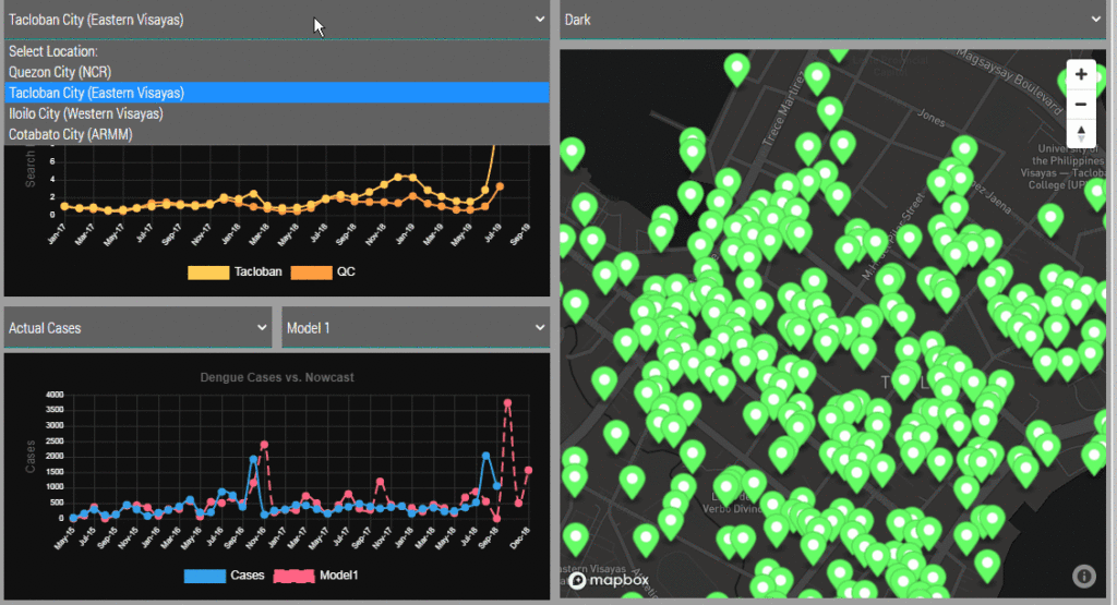
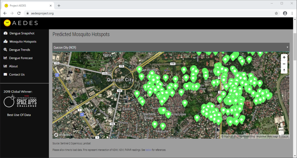
CirroLytix Research Services was formed to create social impact through big data. Through the application of machine learning, data engineering, remote sensing, and social listening, the Philippines-based data analytics firm hopes to help governments, researchers, non-government organizations (NGO), and social enterprises achieve positive change. The Advanced Early Dengue Prediction and Exploration Service (Project AEDES) is one of the CirroLytix’s flagship projects developed during the 2019 National Aeronautics and Space Administration’s (NASA) International Space Apps Challenge. It combines digital, climate, and remote sensing to nowcast dengue trends and detect mosquito habitats to help pre-empt cases of dengue. Project AEDES process leverages normalized difference vegetation index (NDVI), Fraction of absorbed photosynthetically active radiation (FAPAR), and normalized difference water index (NDWI) readings from Landsat and Sentinel-2 to estimate still water areas on the ground, which is correlated with dengue case counts from national health centers.
The Advanced Early Dengue Prediction and Exploration Service (Project AEDES) combines digital, climate, and remote sensing to nowcast dengue trends and detect mosquito habitats to help pre-empt cases of dengue.
Dominic Vincent “Doc” Ligot, co-founder and chief technology officer of CirroLytix, describes Project AEDES as an “early detection of panics from online searches, anticipating case counts from environment readings, but most importantly pinpointing hotspots from mosquito habitat detection.”
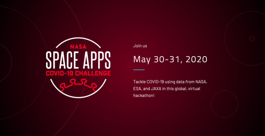
The U.S. space agency National Aeronautics Space Administration (NASA), European Space Agency (ESA), and Japan Aerospace Exploration Agency (JAXA) are inviting coders, entrepreneurs, scientists, designers, storytellers, makers, builders, artists, and technologists to participate in a virtual hackathon May 30–31 dedicated to putting open data to work in developing solutions to issues related to the COVID-19 pandemic.
During the global Space Apps COVID-19 Challenge, participants from around the world will create virtual teams that – during a 48-hour period – will use Earth observation data to propose solutions to COVID-19-related challenges ranging from studying the coronavirus that causes COVID-19 and its spread to the impact the disease is having on the Earth system. Registration for this challenge opens in mid-May.
“There’s a tremendous need for our collective ingenuity right now,” said Thomas Zurbuchen, associate administrator for NASA’s Science Mission Directorate. “I can’t imagine a more worthy focus than COVID-19 on which to direct the energy and enthusiasm from around the world with the Space Apps Challenge that always generates such amazing solutions.”
The unique capabilities of NASA and its partner space agencies in the areas of science and technology enable them to lend a hand during this global crisis. Since the start of the global outbreak, Earth science specialists from each agency have been exploring ways to use unique Earth observation data to aid understanding of the interplay of the Earth system – on global to local scales – with aspects of the COVID-19 outbreak, including, potentially, our ability to combat it. The hackathon will also examine the human and economic response to the virus.
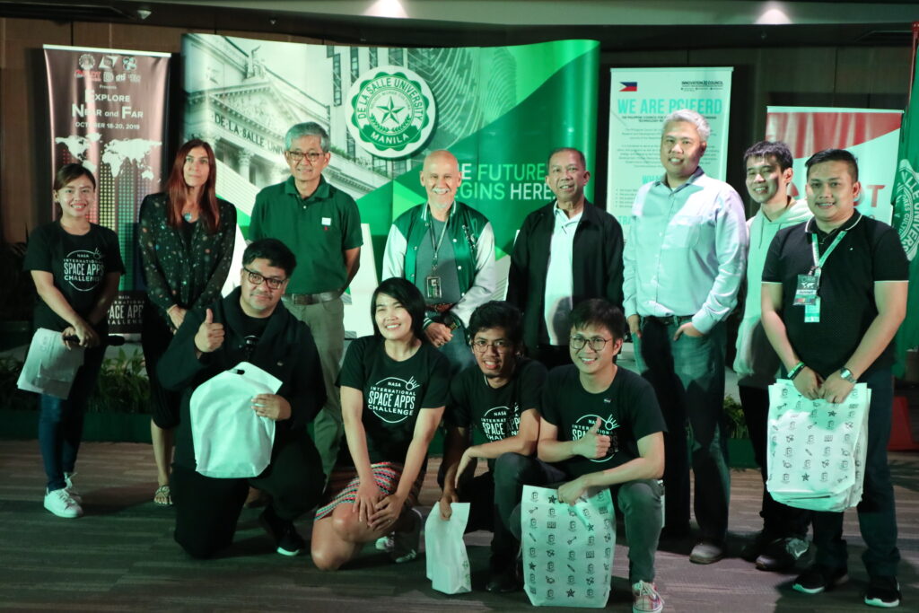
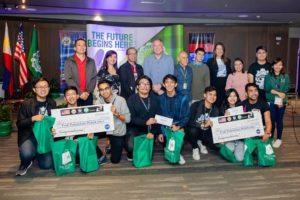
Upper row Associate American Corner librarian Donna Lyn G. Labangon, Space Apps global leader Dr. Paula S. Bontempi, former DICT Usec. Monchito B. Ibrahim, Animo Labs executive director Mr. Federico C. Gonzalez, DOST-PCIEERD deputy executive director Engr. Raul C. Sabularse, PLDT Enterprise Core Business Solutions vice president and head Joseph Ian G. Gendrano, lead organizer Michael Lance M. Domagas, and Animo Labs program manager Junnell E. Guia. Lower row Dominic Vincent D. Ligot, Frances Claire Tayco, Mark Toledo, and Jansen Dumaliang Lopez of Aedes project.
MANILA, Philippines — A dengue case forecasting system using space data made by Philippine developers won the 2019 National Aeronautics and Space Administration’s International Space Apps Challenge. Over 29,000 participating globally in 71 countries, this solution made it as one of the six winners in the best use of data, the solution that best makes space data accessible, or leverages it to a unique application.
Dengue fever is a viral, infectious tropical disease spread primarily by Aedes aegypti female mosquitoes. With 271,480 cases resulting in 1,107 deaths reported from January 1 to August 31, 2019 by the World Health Organization, Dominic Vincent D. Ligot, Mark Toledo, Frances Claire Tayco, and Jansen Dumaliang Lopez from CirroLytix developed a forecasting model of dengue cases using climate and digital data, and pinpointing possible hotspots from satellite data.
Sentinel-2 Copernicus and Landsat 8 satellite data used to reveal potential dengue hotspots.
Correlating information from Sentinel-2 Copernicus and Landsat 8 satellites, climate data from the Philippine Atmospheric, Geophysical and Astronomical Services Administration of the Department of Science and Technology (DOST-PAGASA) and trends from Google search engines, potential dengue hotspots will be shown in a web interface.
MANILA, Philippines — Among the 2,729 teams in 200 locations all over the world who participated in the NASA Space Apps Challenge, an app made by Filipino innovators was nominated first time by NASA scientists and experts to become a finalist at the global level. Altogether, they will join the top 25 in competing for the six winners of the biggest hackathon in the universe.
The winning app seeking to communicate scientific data to fishermen even without Internet connection was made by IT professionals Revbrain G. Martin, Marie Jeddah Legaspi, and Julius Czar Torreda from team iNON, which stands for “It’s now or never.” Named ISDApp, from the Tagalog word “isda” meaning fish, it sends useful information to fishermen such as real-time weather, sunrise and sunset, wind speed, and cloud coverage to plan their fishing activities in catching more fish using the NASA GLOBE Observer app, a data collection from citizen scientists around the world used in concert with NASA satellite data to identify or communicate information, and educating the public about planet Earth. Fishermen will receive SMS notifications from the Amazon Web Services gateway while local government officials would manage their details using a smartphone app connected to the cloud. NASA scientists and experts consider this fisherfolk app made by Pinoys as one of the solutions “with the most potential to improve life on Earth or in the universe,” therefore nominated as global finalist for Galactic Impact.
The fishermen app won in the local level on Friday-Sunday, October 19–21, 2018 at De La Salle University, Malate, Manila, Philippines, in collaboration with the Embassy of the United States of America to the Philippines and PLDT. US Embassy deputy chief of mission John C. Law, PLDT Enterprise Core Business Research and Development head Leandro T. Santos, DOST-Philippine Council for Industry, Energy and Emerging Technology Research and Development deputy executive director Engr. Raul C. Sabularse, Department of Information and Communications Technology senior planning officer Yvette M. Cabrera, and Animo Labs executive director Federico C. Gonzalez served as jurors at the local level.
An emergency checklist kit app designed for disaster preparedness also won at the local level developed by students Jeorge Loui P. Delfin, Bluen Ginez, Samuel Jose, Rainier G. Narboneta, and Eugenio Emmanuel A. Araullo. Other projects and solutions developed during the hackathon are games using images from the Hubble Space Telescope, augmented reality mobile app to tell a story of the changes in the Arctic and Antarctic ice, artificial intelligence app helping scientists confirm the habitability of exoplanets, and story-based game using NASA Earth imagery. They joined together with teams of coders, scientists, developers, designers, storytellers, makers, builders, technologists, thinkers, entrepreneurs, and everyone around the globe working together in a 48-hour sprint to develop solutions to some of the most pressing challenges on Earth and in space, using NASA resources and data.
A day-long data bootcamp was held to learn new concepts, strategies and skills from keynote speakers, panelists, and mentors. Michael Carroll from Urban Engine in Huntsville, AL and NASA Earth Science Division senior advisor Dr. Patricia Jacobberger introduced Space Apps through a virtual talk while NASA astronaut Drew Feustel, orbiting aboard the International Space Station welcomed everyone to the event. US Embassy science fellow Dr. Anondo Mukherjee and US Fulbright fellow Sarah Marie Hartman gave an online lecture about the Earth’s environment. DOST-Advanced Science and Technology Institute acting director Dr. Joel Joseph S. Marciano, Jr. and PHL-Microsat program leader Dr. Marc Caesar R. Talampas discussed microsatellite development and advanced technologies in the Philippines.
Several mentors coming from different backgrounds such as YSEALI alumni Ryan Madrid and Malcolm Flores, De La Salle University professors Jordan Aiko P. Deja and Neil Patrick A. Del Gallego, PHL-Microsat engineers Ariston N. Gonzalez, Lorenzo Sabug, Jr., Benjamin Joseph D. Jiao, and Carlo D. Pastoral, Amazon Web Services developers John Luis Garcia, Dennis Magsajo, and Randy Bardaje, Animo Labs incubatee and MachiBox CEO Simon Gregory Mabanta, VR Philippines lead Cristopher David, Mobility IT 4 Youth lead Art Polo Gabriel III, nuclear physicist Dr. Jasmine Albelda, and entrepreneur Ibba Bernardo guided participants in creating their winning apps and solutions to solve problems on Earth and space. Department of Information and Communications Technology undersecretary Monchito B. Ibrahim gave an inspiring message to the participants. IdeaSpace and Animo Labs looked upon promising projects and solutions that might have a business potential.
During the hackathon period, teams are expected to find solutions to themed challenges put forth by NASA. They work together with the rest of the world on hackathon weekend to devise creative and innovative solutions to these challenges. Projects do not have to be apps and anyone does not need to become a computer programmer to participate. Participants collaborate to build anything — from open-source software, hardware, data visualizations, and citizen science platforms, to videos, art, and other communications solutions — aimed at addressing global challenges. The overarching theme of the 2018 challenges is “Earth and Space,” underscoring the connections between major challenges, and the potential solutions to them, both on Earth and in space. The 2018 mainstage Space Apps event was hosted by Urban Engine in the US Space and Rocket Center at Huntsville, AL, also known as “The Rocket City.”
Since its inception in 2012, the International Space Apps Challenge has become the world’s largest global hackathon, engaging thousands of global citizens to collaborate in building innovative solutions to complex challenges using NASA’s open data. Hackathons are technology development marathons that draw on the talents and initiative of bright-minded people. Space Apps inspires local innovation communities to convene, cooperate, and create.
The 2018 hackathon was organized by Matt T. Keener, Jeanie M. Duwan, Randolf D. Mariano, and Xavier E. Lara from the American Spaces Philippines of the US Embassy and Kai Shan L. Fernandez, Christine M. Abrigo, Donna Lyn G. Labangon, Kevin Anthony Y. Kaw, and Dr. Rafael A. Cabredo from De La Salle University. Another hackathon was organized at Makati-Bonifacio Global City by Womensphere. In the past years, Tzar C. Umang brought Space Apps in Dagupan, Pangasinan on 2016 while Art Polo Gabriel III, Wilson Censon, and Tito Mari Francis Escaño organized one in PLDT InnoLab in Mandaluyong, Metro Manila. De La Salle — College of Saint Benilde also hosted Space Apps on 2017 by Dr. Edward M. Moises, Norman Lee, and Catherine Valdellon-Mojado.
Lead organizer Michael Lance M. Domagas is very thankful that NASA scientists and experts recognized the skills and talents of Filipinos in building projects and open-source solutions that address real-world problems, on Earth and in space, and hoping that Filipinos would win the competition.
MANILA, Philippines — A mobile and SMS application developed by IT professionals Revbrain G. Martin, Marie Jeddah Legaspi, and Julius Czar Torreda to help fishermen receive real-time weather, sunrise and sunset, wind speed, and cloud coverage to plan their fishing activity, and an emergency checklist kit app was developed by students Jeorge Loui P. Delfin, Bluen Ginez, Samuel Jose, Rainier Garcia Narboneta, and Eugenio Emmanuel A. Araullo for disaster preparedness won the NASA Space Apps Challenge on October 19–21 at De La Salle University in Manila, Philippines, in partnership with the Embassy of the United States of America and PLDT.
Other projects and solutions developed are games using images from the Hubble Space Telescope, augmented reality mobile app to tell a story of the changes in the Arctic and Antarctic ice, artificial intelligence app helping scientists confirm the habitability of exoplanets, and story-based game using NASA Earth imagery.
They joined together with teams of coders, scientists, designers, storytellers, makers, builders, technologists, thinkers, designers, entrepreneurs, and everyone around the globe working together in a 48-hour sprint to develop solutions to some of the most pressing challenges on Earth and in space, using NASA resources and data.
Since its inception in 2012, the International Space Apps Challenge has become the world’s largest global hackathon, engaging thousands of global citizens to collaborate in building innovative solutions to complex challenges using NASA’s open data. Hackathons are technology development marathons that draw on the talents and initiative of bright-minded people. Space Apps inspires local innovation communities to convene, cooperate, and create. On 2016, Tzar C. Umang brought Space Apps in Dagupan, Pangasinan while Art Polo Gabriel III, Wilson Censon, and Tito Mari Francis Escaño organized one in PLDT InnoLab in Metro Manila. De La Salle — College of Saint Benilde hosted Space Apps on 2017.
A day-long data bootcamp held on October 19 to learn new concepts, strategies and skills from keynote speakers, panelists and mentors. Michael Carroll from Urban Engine in Huntsville, AL and Dr. Patricia Jacobberger, the Senior Advisor in NASA Earth Science Division, introduced Space Apps through a virtual talk while U.S. Embassy Science Fellow Dr. Anondo Mukherjee and U.S. Fulbright fellow Sarah Marie Hartman gave an online lecture about the Earth’s environment. Acting Director Dr. Joel Joseph S. Marciano, Jr. of DOST-Advanced Science and Technology Institute and Program Leader Dr. Marc Caesar R. Talampas of PHL-Microsat discussed microsatellite development in the Philippines.
Several mentors coming from different backgrounds taught participants in the data bootcamp in the form of stardust stations. Stardust stations is an alternative to a lecture format and encourages learning through participatory activities. A stardust station can show applications of data, demonstrate simple hardware projects or teach other hackathon skills. Neil Patrick Del Gallego and Jordan Deja from De La Salle University taught augmented reality and user experience, respectively. Engr. Ariston N. Gonzalez, Lorenzo Sabug, Jr., Benjamin Joseph D. Jiao, and Carlo Dizon Pastoral from PHL-Microsat discussed using Diwata-1 API. Animo Labs incubatee Simon Gregory Mabanta discuss about educational robotics. John Luis Garcia, Dennis Magsajo, and Randy Bardaje taught using Amazon Web Services cloud. Art Polo Gabriel III, the organizer of Space Apps 2016 from Mobility IT 4 Youth, explained the use cases of smartglass applications.
During the hackathon period on October 20–21, teams are expected to find solutions to themed challenges put forth by NASA. They work together with the rest of the world on hackathon weekend to devise creative and innovative solutions to these challenges. Projects Apps projects don not have to be apps and anyone does not need to become a computer programmer to participate. Participants collaborate to build anything — from open-source software, hardware, data visualizations, and citizen science platforms, to videos, art, and other communications solutions — aimed at addressing global challenges.
The overarching theme of the 2018 challenges is “Earth and Space,” underscoring the connections between major challenges, and the potential solutions to them, both on Earth and in space. The 2018 mainstage Space Apps event was hosted by Urban Engine in the U.S. Space and Rocket Center at Huntsville, AL, also known as “The Rocket City.”
YSEALI alumni Ryan Madrid and Malcolm Flores, Dr. Jasmine Albelda from the Philippine Nuclear Research Institute, entrepreneur Ibba Bernardo, and technologists like Cristopher David and Simon Gregory Mabanta served as mentors in the hackathon proper. IdeaSpace and Animo Labs looked upon promising projects and solutions that might have a business potential. Sentinel Hub, Neustar, Amazon Web Services, Microsoft, and IBM offered the use of their technologies for the participants during the hackathon.
After the development period, teams are expected to provide a four-minute presentation about their projects and solutions. Deputy Chief of Mission John Law of the Embassy of the United States of America to the Philippines, Leandro T. Santos, Head of PLDT Enterprise Core Business Research and Development, Deputy Executive Director Engr. Raul C. Sabularse of DOST-Philippine Council for Industry, Energy and Emerging Technology Research and Development, Senior Planning Officer Yvette M. Cabrera from the Department of Information and Communications Technology, Executive Director Federico C. Gonzalez of Animo Labs served as jurors for the Space Apps hackathon.
Jeanie Duwan, Randolf Mariano, and Xavier Lara from the American Spaces Philippines of the US Embassy and Christine M. Abrigo, Donna Labangon, and Kevin Anthony Kaw from De La Salle University organized Space Apps in the Philippines on 2018. Space Apps Philippines lead organizer Michael Lance believes that Filipinos can build projects and open-source solutions that address real-world problems, on Earth and in space. #SpaceApps #SpaceAppsPH